Two maps from
L. Vernon Briggs'
History of Shipbuilding on North River,
Plymouth County, Massachusetts
Boston, 1889
L. Vernon Briggs wrote this history of shipbuilding in northern Plymouth Colony (Scituate, Marshfield, Pembroke, and Hanover) many years before his famous three-volume genealogical study of the Briggs family History and Genealogy of the Briggs Family, 1254-1937, which he completed in 1938.
That book is now (2012) on line at http://archive.org/details/historyofshipbui00brigg.
Included here are scan's of two of his hand-drawn maps that appear in his shipbuilding history. The first is a map of Pembroke in 1794, and the second is a detailed map of the North River (which is the north boundary of Pembroke) from Barstow's Bridge to the Third Herring Brook. The second map (which has north down instead of up) can be located on the Pembroke map at the North RIver Bridge where the road from Plymouth to Boston crosses the North River, and "shipyard" and "brick kilns" are written on the Pembroke map.
Map of Pembroke, AD 1794
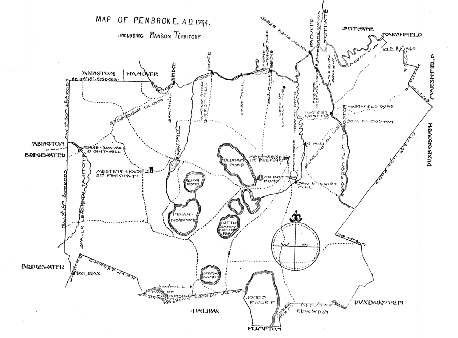
Content of the map.
- Neighboring towns, with borders listed in rods and inclination. Starting with Marshfield in the northeast and going counterclockwise, Scituate in the northeast, Hanover in the north, Abington in the northwest, Bridgewater in the southwest, Halifax in the southwest, a bit of Plimpton in the south, and Duxborough in the southeast.
- River. The North River forms the northern boundary of Pembroke. Along the river, starting from Marshfield in the east and going west: shipyard, brick kilns, 3rd Herring Brook, North River Bridge, Herring River, head of common tide, forge & anchor shop bridge, saw mill, pond, gristmill, forge, a brook, bridge at road to Bridgewater, and sawmill.
- Roads. The highway from Plymouth to Boston runs from south to north in the eastern part of town, ending at the North River Bridge (see the next map for detail at the bridge). Other roads are dotted lines, most not labelled.
- Several ponds and brooks. A modern map will show these more clearly.
- Meeting houses. The 1st Precinct Meeting House is in the east half of town, to the east of Oldham Pond. The 2nd Precinct Meeting House is in the west half of town. The Friends Meeting House is near the North River Bridge on the highway from Plymouth to Boston.
- Various other buildings. Listed from the west to the east: forge, saw-mill, and grist-mill; sawmill; sawmill; sawmill; anchor shop & grist-mill; forge; grist-mill; sawmill; saw & grist mill; g mill; and Turner's gristmill.
North River, from Barstow's Bridge to the Third Herring Brook
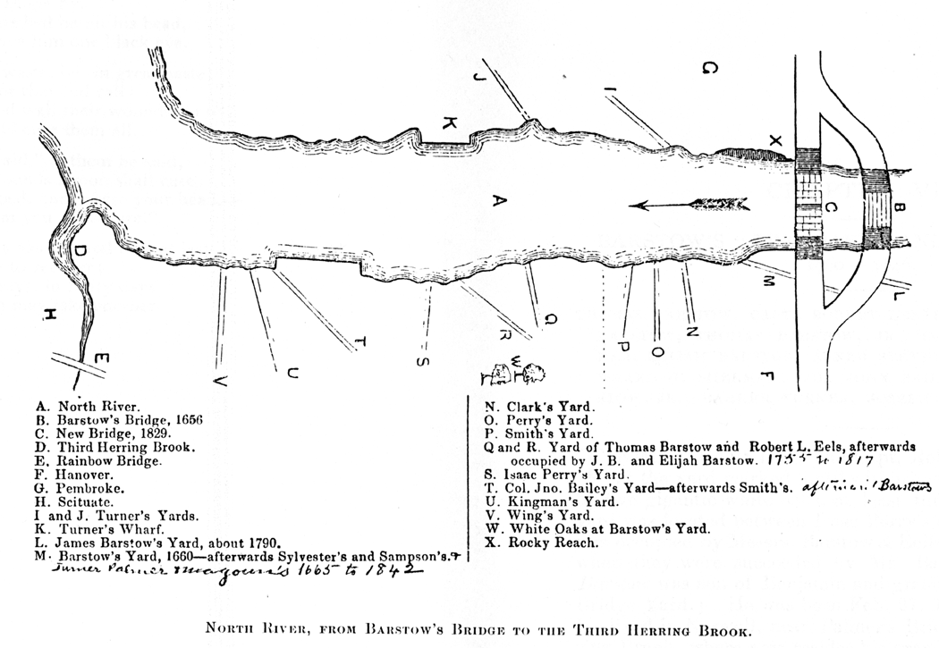
Note that Scituate, which is northeast, is at the bottom of the map, while Pembroke, which is southwest, is at the top of the map. (The arrow points downstream, not north.)
Map key. (Someone's handwritten comments in this copy of the book are put in square brackets.)
A. North River.
B. Barstow's Bridge, 1656.
C. New Bridge, 1829.
D. Third Herring Brook.
E. Rainbow Bridge.
F. Hanover.
G. Pembroke.
H. Scituate.
I and J. Turner's Yards.
K. Turner's Wharf.
L. James Barstow's Yard, about 1790.
M. Barstow's Yard, 1660–afterwards Sylvester's and Sampson's. [Turner Palmer Magoun's 1665 to 1842]
N. Clark's Yard.
O. Perry's Yard.
P. Smith's Yard.
Q and R. Yard of Thomas Barstow and Robert L. Eels, afterwards occupied by J. B. and Elijah Barstow. [1755 to 1817]
S. Isaac Perry's Yard.
T. Col. Jno. Bailey's Yard–afterwards Smith's. [afterwards Barstow's]
U. Kingman's Yard.
V. Wing's Yard.
W. White Oaks at Bartstow's Yard.
X. Rocky Reach.
D. Pane-Joyce
Sept 2000. Updated Aug 2012. All rights reserved
Located at http://aleph0.clarku.edu/~djoyce/gen/scituate/Briggs.html