Town of Clifton Park
New Topographical Atlas of Saratoga County, New York
Stone & Stewart Publ., Philadelphia, 1866
The town of Clifton Park is located in the southern part of Saratoga County along the Mohawk River. It is bounded on the east by the town of Half Moon, on the northeast by the town of Malta, and on the northwest by the town of Ballston. The populatio of Clifton Park in 1865 was 2712.
This map is on page 19 of the Atlas. There are separate insets for the more built up parts of town, namely for Clifton Park Village, Jonesville, Rexford Flats, and Vischers Ferry.
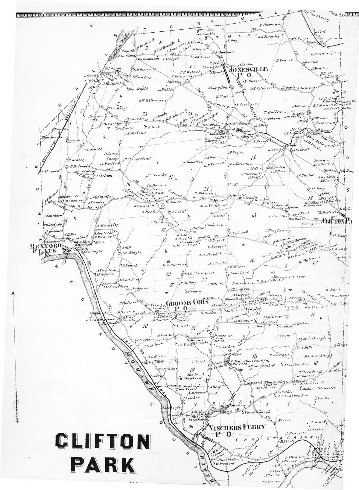
Transcription of the names on the map.
A transcription of the names is useful for two reasons. First, sometimes the words are not too easy to read on the scanned map. Second, you can search the transcription of names, then find the name on the map.
Most of Clifton Park is composed of the Clifton Park Patent, the central part of town. At the far south is Canistagajoni. Apple Patent is in the west starting from Rexford Flats and going to the northeast. In the northwest and north of town is part of the Fifth Allotment, and in the northeast is apparently part of the Saratoga Patent (or perhaps it's more of the Fifth Allotment).
Clifton Park Patent. Sections numbered up through 35, starting in the southeast.
§ 2: J. Fowler, J. Cassler, Jos. Fowler, I.S. Wilbur.
§ 3: S. Wilbur (2), A.V.V. Pierce.
§ 4: S. Keeler.
§ 6: M. Van Vranken, J. Vandenburgh.
§ 7: A. Best.
§ 8: A. Best, S. Althouse, Woolen Mill, S. Webster, I. Vischer.
§ 9: S. Mill.
§ 10: F. Dings, H.J. Steenburgh, N. Sheffer, D. Steenburgh, S.H. No.15, W. Rumpass, R. Ostrom, T.A. Mills, J.J. Steenburgh, J. Cramer.
§ 11: S. Lockrow, Z. Bain, J. Teachout, A. Adsit, H. Filkins, C. Westfall, J. Peters, P. Doty.
§ 12: M.M. Fry, R. Philips, J. Turner, S. Shoefelt, J. Clapper, Dowse, J. Fellows, Mrs, Gregory, W.C. Tourtelot, W.M. Millis.
§ 13: N.D. Hawley, E.F.Reed, G. Gregory, Clifton Park Village, R. Dedrich, M.E. Ch., H. Harrison, Mrs. Shouch, E. Doty, J.H. Clark, A. Doty, L. Doty, G. Taylor, Toll House.
§ 14: School Nu. 10, M. McMann, A. Hubbs, S. Mill, J. Higgins, G. Higgins, L. Hayner, J. Wood, W.B> Wooden, S. Mill, J. Ostrom, G. Follet, H. Rogers, Mrs. Sherman, Gage.
§ 15: J. Arnold, W.J. Arnold, C. Brooks, W. Sickler, J. Ostrom, P. Ostrom (2), J. Flagler.
§ 16: School No. 6, J. Peck Jr., J. Ostrander, M. Woodward, Dr. H.C. Cooper, Mrs. Sherwood, J. Hicks, P. Ostrom, R. Keeler, A. & J. Clark.
§ 17: A. Flagler, O. Knowlton, C. Flagler, S. Mill, D. Pickett, J. Pascal, J. Millios, H. Link, W. Egan, B.S. Sh., B. Kiffin, School No. 5, J. Lockrow, F. Warner, N. Mons, E.I. Moul, S.W. Pearsull, C. Spooneckel.
§ 18: A.A. Van Vranken, J. Van Vranken, A.R. Van Vranken, W.E. Link, E.V. Welden (2), s. Mill, N.F. Vischer.
§ 19: I. Irish, Mrs. Irish, W. Shepherd, R. Shepherd, Mrs. Nessel, G. Vischer (3), S. Fonda, T. Hall, J. Hall.
§ 20: J. Hall, M.L. Keeler, A.J. Caldwell, L.L. Leversee, J. Fonda, R. Betts, D. Lester, H.M. Chase, H. Palmer, N. Vissher.
§ 21: (south to north) B. Briggs, C.C. Vischer, M.E. Church, Cem. Parsonage, N.F. Vischer, A. Hegeman, F.J. Vischer, S. Abrams, N.F. Visscher, A.J. Caldwwell, School No. 2, G. Van Wie, G. Palmer, J. Palmer Nursery, Mrs. Hoves, C.F. Fort, W. Sh. & R.S. Sh, S. Groom, Store & P.O., Grooms Cor's P. O., E.N. Visscher, D. Bocas, J. Miller, H.M. Best, J. Groom, C.D. Hicks.
§ 22: A. Clark, J.M. Clark, G. Lossee, P. Bogart, L. Benedict, Parsonage, Bapt. Ch. (Boundary between section 22 and section 23 unclear.)
§ 23: Bulson, P. Johnson, A. Mott, J. Van Vranken, H. Masselle, A. Althouse, L.P. Travers, A. Bower, A. Smith.
§ 24: D. & G.H. Hubbs, Wm. H. Brewster, S. Brewster, G. Kennedy, R.R. Kennedy, J. Hubbs.
§ 25: H.W. Williams, M. Brooks, B.F. Irish, J. Filkins.
§ 26: P. Jones, Carey, O. Slingerland, L.W. Crosby, I.W. Barnes, N.G. Smalley, N.G. Peck.
§ 27: N. Mortimer, J.J. Jones, O.H. Wait, J. Negus, Cem., O.H.W., Sch. No. 7, J. Ferguson, S. Peck, L. Jones, P. Arnold, J. Donally, I. Brooks.
§ 28: P.M. Doty,
§ 29: A. B. Champion.
§ 30: D.G. Harris.
§ 31: J. Peck, B.S. Sh.
§ 33: W. Sh., S. Peck.
§ 34: S. Peck, P. Arnold.
§ 35: S. Peck, J. Ferguson, L. Jones.
§ 36 (near Vischers Ferry): G. Vischer.
§ Unnumbered rectangular section between sections 20 and 26: J. Ferguson, School No. 14, N. Brunk, D. J. Knight, J. Hill, E.T. Hayes, J. Appleton. Unnumbered section along Mohalk River east of Rexford Flats (north to south): J. Smalley, C. Kingsley, H. Nott, Mrs. Wright, A. Knowlton, A.M. Scrafford, J.H. Fonda, W. Fonda, Store, P.A. Fonda.
Canistagajoni, starting at Vischers Ferry in the west and going east:
C. Vickry, S.H. No. 16, S. Cragier, Mrs. Althouse, J. McDermont, A. Van Vranken, J.W. Van Vranken, J. Pierce, J.J. Clute, Mrs. Folley, I. Pierce, S. Keeler, M. A. Forte, A.G. Pierce, A. Pierce, N.J. Forte, N.N. Forte, J. Pierce, D.S. Webseter, J. Fowler, S.H. No. 4, Mrs. Frazier, Store, J.W. Fowler, J. Carnel, Dry Dock, B.S. Sh., N.J. Clute, P. Conner, I. Bliss, P. Flinn, M. Shiver, Dr. F. Holland, J. McGloucen, H. Dunsbach, J. Flinn, Wm. E. Shurtliff.
Apple Patent. This runs from the village of Rexford Flats on the Mohawk River northeastward.
Mrs. Wolfe, Store, E. Rexford, A. McKain, Grave Yard, C.W. Rexford, S.H. No. 1, J.D. Rexford, J. Southard. L.R. Gurnsey, C. Dubois, N. Sheldon, C. Eaton, C. Rexford, J. Smith, Mrs. Banta, Banta's Est., M.. Lotridge, S.H. No.[?], T. Crowley, Mrs. Arnold, J.P. Smith, I Schauber, I. Schauber, and E.D. Guernsey.
Fifth Allotment. To the west of Apple Patent going north:
J. Southard (2), T.E. Hayner, Mrs. Hayner, S.A. Daggett.
§ 1: B.D. Arnold, R. Bentley, H. Van Buren, G. Prence.
§ 2: S. Stewart.
§ 3 (including part north of Apple Patent): A.B., S. Sleath, D. Crosby, J. Rouch, W. Cain, M. Lotridge, A. Smith, E. Southard, G. Brownell, Wm. McIlreath, Mrs. Hammond, H. Armstrong.
§ 4: F. Beers, E. Shepard, P.E. Wetzel, J. Kingsley, J. & W. Davis, D. Davis, E. Leers, W.G. Hubbs, Wm. Culver.
East section, including Jonesville, starting from the south: P.J. Schermerhorn, K. Gurensey (2), W. Wait, Cem., W. Wait, S. Langdon, S.Y. Davie, T. Slaton, Jonesville P.O., J. Wichs, Hotel, J. Mulligan, L. Gage, J.H. Murphy, P. Sherman.
Saratoga Patent, two sections in the northeast of town.
West section, starting from the south: A. Wood, J.J. Best, A. DeGroff, T. Bailey, M. Adsit, J. Wilson, B.N. Sylvester, T, Doyle, A. James, T. Bendon, G. Dator, H. Traver, N.C. Sweet, E. Bendon, P. DeGroff, J. Vial, L. Van Hyning.
East sectin, from the south: J.C. Kellogg, C. Butler, S. DeGroff, Donihue, P. Butler, J. Huested, S.H.No.11, Mrs. C. Mills, S.B. Flader, A. DeGroff, S.B.F., S.T. DeGroff, A. DeGroff, P. Coleman, C. Wilson, A. Burk, M. Adsit, J.W. Sweet, R.P. Kennedy, R. Ostrom, L.E. Sheldon, J.C. Payne, S.H.No.13.

D. Pane-Joyce
April 2002. All rights reserved
Located at http://aleph0.clarku.edu/~djoyce/gen/saratoga/Atlas.html